


Welcome to the SOPAC, CSRC and MEaSUREs ESESES website
The Scripps Orbit and Permanent Array Center (SOPAC) web site now includes the web pages of the California Spatial Reference Center (CSRC) and the MEaSUREs (Making Earth System Data Records for Use in Research Environments) ESESES ("Extended Solid Earth Science ESDR System") project, a collaborative NASA program with Caltech's Jet Propulsion Laboratory (JPL).
News 9/21/2023: SIO has been chosen as one of 4 institutions to receive an FY23 Geospatial Modeling Competition Award by NOAA's National Geodetic Survey (NGS) (Yehuda Bock, Principal Investigator). SIO is receiving $1,300,000 annually for a potential total of $6,500,000 over a 5-year period for a project titled "NSRS Intra-Frame Deformation Model and New SIO Geodesy Program." The primary objectives of this project are to create a formal geodesy program in support of the nationwide deficiency of geodesists and to modernize geodetic models for the NSRS.
The three entry points under a single unified Web structure:
We have organized the Web pages horizontally as a series of main headers, each linked to a series of vertical subheaders.
Information specific to each of the centers is located under the main headers “SOPAC”, “CSRC” and "MEaSUREs."
 The SOPAC data archive is common to all programs so we’ve created a single main header “Data Archive.” Similarly, all applications are organized under one main header “Applications.”
We’ve created a single main header, “CRTN” for the California Real Time Network.
The “Maps” main header contains a new map interface for the California Spatial Reference Network (CSRN) and CRTN.
The main header “Contact Us” reflects the overlap of SOPAC and CSRC personnel and indicates the primary contacts for each center and individual.
Movie below shows solar panel upgrades at Modjeska peak, a primary communications hub for the Orange County stations of CRTN (courtesy Art Andrew, Orange County Public Works).
12/20/2022 10:34:24 UTC: Minimal effect on coordinates for M6.4 Ferndale earthquake, N26.43123,W140.09766; 17.9W km depth. The earthquake caused a minimal shift in coordinates - maximum horizontal offset of 0.066 ft (2 cm) at station P161, less than 1 cm at other stations in the epicentral region. No detectable vertical motions.
SOPAC and CSRC News
In Memoriam: John Canas
CSRC Strategic Plan/Decade 3 published (2021-08-31)
![]()
June 16: The CSRC 2017.50 map is now accessible via QR code. Use the QR code below. (If needed, instructions are available here.)

Paper published on early postseismic deformation in Science Advances (2021), Jiang, Bock & Klein
Bock & Wdowinski GNSS review paper: IEEE, 2021, 741-820, doi: 10.1002/9781119458449.ch28.
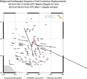
Update August 30, 2019: July 4,6 2019 Ridgecrest earthquakes
Coseismic offsets (corrected 11/4/2019)
Epoch 2019.55 coordinates for affected stations
SOPAC computed coseismic offsets using the GAMIT/GLOBK software with 30s data from 98 continuous GNSS stations that experienced total displacements greater than 3 mm.
click here to learn more.